
1849 Montecillo
Montecillo Ground holds a number of ‘firsts’ in Dunedin sports. It was the venue of the first anniversary games, held in March 1849, which were followed by the first horse race held in Otago. In the same year, Dunedin’s first cricket pitch was prepared on the site. In 1890 the combined Zingari-Richmond Club began its occupation of the ground.
1846 – 1880 Arthur St and York Place
The Arthur Street (or York Place) cemetery was set aside for that purpose in the original survey of Dunedin, and the first burial (1846) was of one of the surveyors’ labourers. It remained Dunedin’s only cemetery until 1858, when the Southern Cemetery was opened. In 1861 the discovery of Gold saw the arrival of soldiers from the 70th Foot to keep order on the goldfields. They were originally camped on the York Place site, moved to the Arthur Street School site and eventually built barracks where the rector’s residence is at Otago Boys’ High School in Arthur Street. An adjacent portion, where Otago Boys’ High School now stands, was used in 1863 as the site of a ‘temporary’ lunatic asylum, which remained until 1884. The condition of the graveyard was finally addressed in 1880, when the gravestones were cleared away and the Council erected in their place a single obelisk bearing the names of those known to be buried there.The portion of the reserve incorporating the former graveyard was redeveloped by the Council in 1945-46.
1857 Southern Cemetery
Concerns for the provision of new burial grounds in 1857 led to the recommendation by the Dunedin Town Board that a site at ‘Little Paisley’ in the southern end of Town Belt be put aside for this purpose. Soon after on 1st April 1858 the Southern Cemetery was opened with the burial of David McGibbon aged 6 years 4 months. The cemetery contains 22,639 burials and was divided into 5 different sections based on the main religious denominations of the time including Anglican, Jewish, Catholic, Presbyterian and Chinese.

1860 – Robin Hood Park (The Imperial Ground)
The park along with the adjacent portion of the Town Belt was used during the early 1860s as a camp for soldiers brought in to police the heady days of the gold rush. The first development of the reserve for sports was in 1881, when the Roslyn Cricket Club was permitted to clear an area near the Roslyn tramline above City Road for a cricket ground. The ‘Tramsheds Ground’, occasionally called the ‘Imperial Ground’ after an early football club established in 1884. The old quarry was used for pistol practice and as a rifle range in 1910-12. Considerable planting of specimen trees was undertaken by the Amenities Society during 1913, and by the Council in 1927. Robin Hood Park was developed with the conversion of the former quarry to a playing field in 1960. A site in the upper portion of the reserve was chosen in 1862 for the construction of a geological survey office and meteorological observatory, subsequently relocated in 1864 to a more open site near Sligo Terrace, and since removed. By 1922 with telescopes provided by J C Begg and Arthur Beverly the observatory opened. The Royal visit in 1954 was commemorated by the construction of a lookout, designated ‘Queen’s View’ across the city and Otago Harbour.


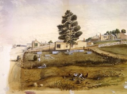
1863 The Dunedin Botanic Garden
The Dunedin Botanic Garden was established in 1863 by the Otago Provincial Council on a site bounded by Castle, Leith, Albany and St David Streets, today occupied by the University of Otago. On 5 January 1863, Alexander Begg was appointed as Gardener of the Recreation Grounds including the Botanical Garden Reserve. The first public occasion on the site was the planting of two memorial oaks on 30 June 1863 to celebrate the marriage of the Prince of Wales. One of those oaks survives today near the children’s playground. These events confirm the claim for the Garden to be the first Botanic Garden established in New Zealand.
On its first site the Garden quickly developed into a fledgling ornamental garden with a propagation unit designed to supply trees for public areas throughout the province. A major flood in February 1868 led to the decision of the Provincial Council to transfer the Garden to its present site. This land was part of the Town Belt reserve set aside at the beginning of planned settlement. There is some evidence of pre-European occupation. In the gold rush period in 1861-63, the flat area became a campsite for diggers on their way to the goldfields. The Dunedin Botanic Garden continues to flourish today as a garden of international quality.

The Botanic Garden Site 1860’s
1872 Creation of the Northern Cemetery
Planning of a new ‘Northern Cemetery’ drew considerable opposition and debate out of concerns for the preservation of the Town Belt, and subsequently a Bill introduced to the General Assembly supporting the cemetery development in 1868 was thrown out. As the need for a new burial ground grew more urgent the Northern Cemetery Act of 1872 was introduced and passed setting aside 20 acres of the Town Belt for a cemetery. The Northern Cemetery was opened in 1872 with the first recorded burial being Ada Massey the infant daughter of the Town Clerk on December 2nd and closed to burials in 1937. Family plots may still be used for burials providing space is still available in the plot however such occasions are now relatively rare. The cemetery contains 17,758 burials representing many different religious denominations and includes the tomb of William Larnach.

1873 – The addition of Woodhaugh Gardens
At the time of European settlement, the Leith Valley was heavily wooded, and this, combined with the relatively easy access to a fast-flowing water supply, resulted in its early development for industry. The name ‘Woodhaugh’ is reputed to have been given by W H Valpy, the wealthy entrepreneur who in 1850 established a sawmill (and later a flour mill also) upstream of the Town Belt. The forest had already been worked over for ships’ fuel and spars, and it is likely that the millers who followed Valpy in establishing businesses alongside the Leith made use of timber from the Town Belt. The tailrace from Valpy’s (later McGlashan’s) mill crossed Duke Street to enter the Town Belt near the western corner of Woodhaugh Gardens, and a mill dam was formed within the Town Belt with a pipe feeding to Stevens and Love’s flour mill (on the present Wilson’s Distillery site). It is also recorded that two members of the McGlashan family were buried in a private cemetery on the Town Belt ‘almost opposite the mill’.
The Woodhaugh section of the Town Belt was already popular for picnics in the 1860s, but its development for the purpose was not planned until 1873, when S H Mirams prescribed in his proposals for the Town Belt that ‘this part could, if required, be best treated as a garden. The Water of Leith winds through it, and by opening suitable channels one or two ornamental islands might be formed, connected with the rustic bridges’. The Woodhaugh development was eventually held back by lack of funding until 1895, when the Council secured unemployed labour to carry out the structural work. Walks through the bush were in place by 1896, and in 1899 the road frontage along Duke Street was laid out with beds of flowering shrubs interspersed with lawn. The vegetation of Woodhaugh Gardens was by now considerably altered from that originally present. Gorse and elderberry were especially rampant, and stumping of these weeds a major task. They were replaced by native plants, but the Council records are silent on any aspect of these plantings other than the quantities.
In 1902 the channel of the Water of Leith, which formerly took a circuitous course, touching Queen Street and then bounding private properties on its way to George Street, was straightened. The former channel and adjacent low land were taken, not without local protest, for a municipal tip which operated until 1905. Planting of the tip site was undertaken in 1906-10: along with the plagianthus still standing today, and an avenue of chestnuts was set out. The Water of Leith in the vicinity provided a number of favourite swimming holes, but several fatalities led to Council expenditure in 1902, and again in 1908, on development of a safe bathing basin. The regular flooding of the Water of Leith appears to have caused little damage to Woodhaugh, however it was necessary after the severe floods of 1923 and 1929 to undertake flood protection works along the urban section of the Leith. Both the deepening of the channel upstream (1923) and its straightening at Willowbank (1956) would have contributed to the lowering of the water table which originally supported the Woodhaugh bush. In 1959 the section adjoining Woodhaugh was also deepened and straightened and a boulder trap constructed, requiring the felling of some vegetation.

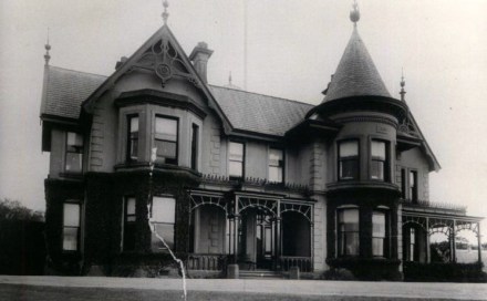
1881 Roberts Park
The park’s name commemorates Sir John Roberts, prominent Dunedin businessman, Mayor and Provincial Councillor, who acquired the property in 1881, and built his residence, Littlebourne House, in 1890. On his death in 1934, the Roberts family offered the house and grounds to the City for vice-regal residence or, failing that, for such other civic or public purpose as the Council may decide. On transfer to the Council under terms of a Trust Deed the house came under the Superintendent of Reserves’ management, and was used from 1938 for student accommodation, then from 1942 was occupied by the Army for the duration of World War II. In 1949 the house was demolished to make way for the realignment of Stuart Street (then Albert St) providing bricks for a number of reserves buildings, principally the departmental offices at the Botanic Garden. The flagstaff was re-erected at the Otago Yacht Club’s rooms. Of the buildings on the site, the garage and sheds were retained, and in 1957 the Roberts Park sportsfield was developed.

Leave a comment